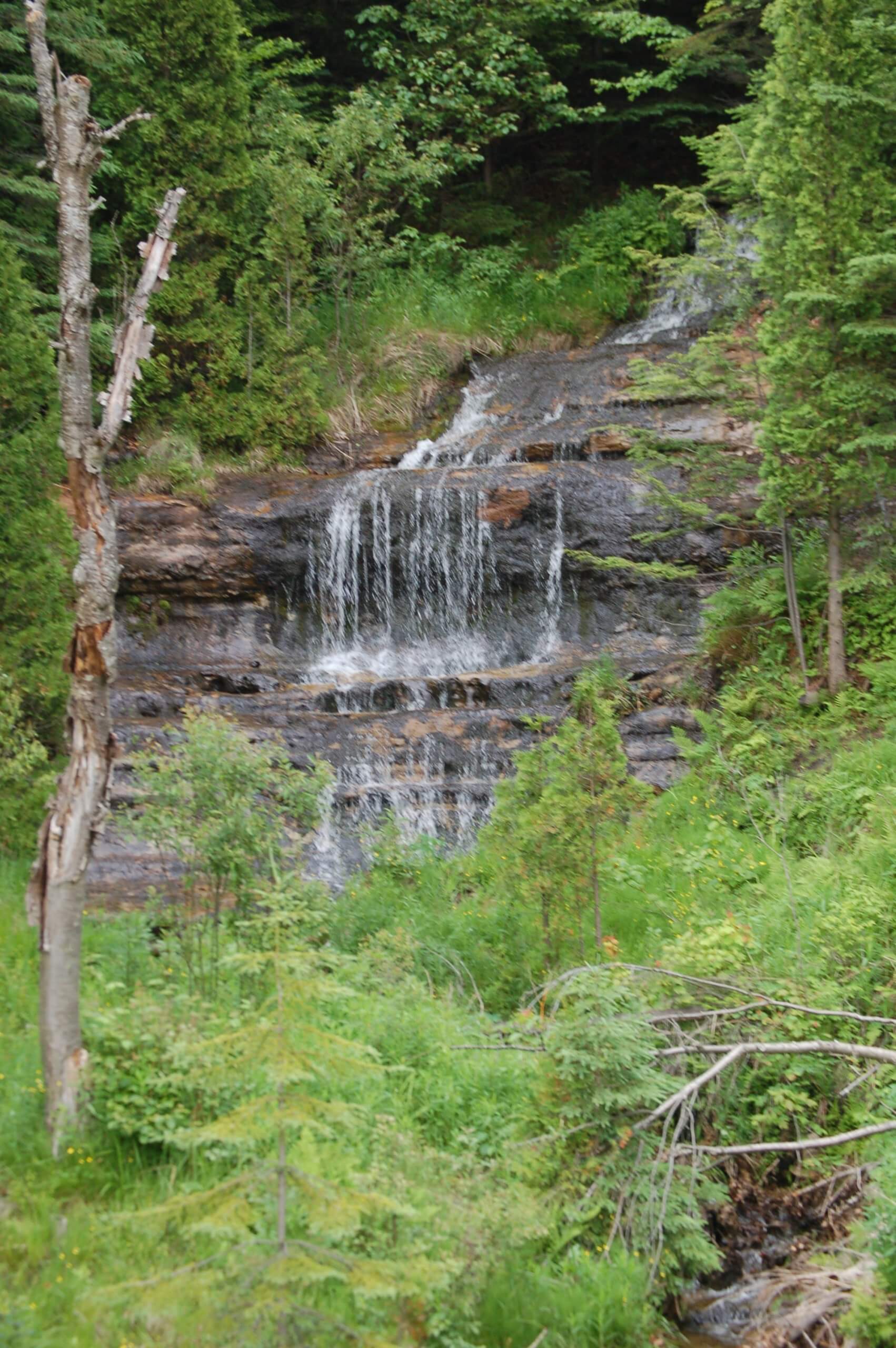
Lake Superior Waterfalls
Did you know there are over 90 waterfalls on the Lake Superior Circle Tour? When you think about it – falls are simply rock and water. So why are we so enamored with them? Why do they capture our imagination and captivate our souls? Is it the CALM we feel listening to a trickling cascade? Is it the MAGIC of the rainbow colors dancing in the mist? Is it the THRILL of being near something so powerful it can provide electricity to 60,000 homes? Is it all of the above? Whatever the reason, it is clear that people LOVE waterfalls. From the mysterious Devil’s Kettle to the jaw-dropping Kakabeka Falls coined the “Niagara of the North” – the Lake Superior Circle Tour offers a flow and fall for every mood.


Tahquamenon Falls
Located near the township of Paradise, Tahquamenon Falls are found within Tahquamenon Falls State Park in Michigan’s Chippewa County. The Upper Falls are a majestic 50 feet high and over 200 feet wide. The centerpiece of the park, these are the largest falls east of the Mississippi River. The water here has a rich amber coloring due to the tannins leaching from the surrounding trees. There is a paved pathway leading from the parking lot to observation platforms. The Lower Falls are a series of five small falls found along a 4 mile (6.5km) trail that hugs the edge of the Tahquamenon River. They can be viewed from shore or reached by boat. Row boats can be rented at the park concession.

Sable Falls
Sable Falls, cascading over a 75 foot drop, is located along the Sable Creek near Grand Marais, Michigan on the eastern side of the Pictured Rocks National Lakeshore. The base of the falls can be accessed from the parking area, via a set of 168 steps. Continuing along the creek will bring you to Sable Beach on Lake Superior.

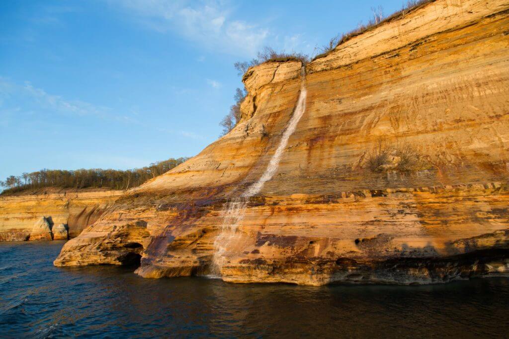
Spray Falls
Spray Falls is located on the Pictured Rocks National Lakeshore, about 22 miles northeast of Munising, Michigan. This impressive waterfall drops directly into Lake Superior over a 70 feet high cliff. Remote and best viewed from the water, 200 feet below the base of the falls rests the remains of the “Superior”, a ship that succumbed to the Lake in 1856. Tours from the water are available for hire via Pictured Rock Cruises. Alternatively, you can launch your kayak from Twelvemile Beach and paddle to the waterfall from there. Although the Lakeshore North Country Trail passes over the top of the falls it is not the best view. You can also view the falls from land via a lookout point east of the falls.

Chapel Falls
The Pictured Rock National Lakeshore is also home to Chapel Falls, located approximately 15 miles east of Munising and accessed via a 1.2 mile hike down the Chapel Loop Trail. The first view of this 60 feet tall waterfall is from a platform near the top of the cascade. There are no pets allowed on this trail, and ample parking is available at the Chapel Basin Parking Lot.

Mosquito Falls
To access Mosquito Falls, located in the Pictured Rock National Lakeshore 15 miles east of Munising, follow the Mosquito Beach Trail for approximately one mile. River otters and beaver have been spotted playing in the stream of this 8 feet high fall on the Mosquito River. There are no pets allowed on this trail.
Bridal Veil Falls
The tallest in Michigan, Bridal Veil Falls is an impressive 140 feet cascade that flows down along the sandstone slide into Lake Superior. Located near Munising, Michigan it is found along the Pictured Rocks National Lakeshore. Although best viewed from the water, it can be seen via land from a distance at the Miners Castle overlook or from Miners Beach. Pictured Rock Boat Cruises can bring you to the waterfall or it can be accessed by kayak. The flow is strongest and most beautiful in the spring, slowing to a trickle moving into summer and fall.

Miners Fall
The most accessible waterfall along Pictured Rocks National Lakeshore, Miners Falls is located in Munising, Michigan. A hop, skip and jump of under one mile takes you from the parking lot to the falls, where two platforms give you a great view of this 50 feet tall waterfall as it cascades over a sandstone cliff. Leashed dogs are allowed on this trail.

Munising Falls
Munising Falls is one of the easiest to visit within Alger County. Found within the Pictured Rocks National Lakeshore, a ¼ mile paved trail beginning at the Munising Falls Visitor Center brings you to two sets of stairs that lead to viewing platforms. The falls boast a 50 feet high drop over a sandstone cliff. Dramatic ice formations make this a popular site in the winter. Leashed dogs are allowed.

Olson/Tannery Falls Trail
Olson Falls (A.K.A. Tannery Falls) Trail is located near Munising, Michigan and is a quick ½ mile round trip walk along Tannery Creek. The gravesite of Rudolph M. Olsen (1909-1982) can be observed along the path. A sandstone cave is tucked behind the 40 feet tall waterfall that can be accessed by visitors. The site is best visited in spring or after heavy precipitation, and dogs are not allowed on the trail. Memorial Falls can be found close by and is accessed via the same trail.

Memorial Falls
The Memorial Falls are sometimes referred to as Twin Falls as they are different cascades in adjacent gorges. Located in Munising, you can access these falls by following a short trail to the top where a small wooden bridge allows you to cross above the falls. Another trail leads to the bottom of the falls. Take the trail that forks off from this one to discover nearby Olson/Tannery Falls.
Alger Falls
Alger Falls is a great roadside attraction, with a series of ledges of varying sizes, with the largest drop measuring approximately 15 feet. The best time to visit is during the spring or after a heavy rain.

Wagner Falls
Wagner Falls is an official State Scenic Site, and is located just 2 miles east of Munising, Michigan. This scenic waterfall is easily accessed from the parking area by following a short pathway to a boardwalk and observation deck overlooking the falls. It is close in proximality to Wagner Falls, which is also easily accessible.

Horseshoe Falls
Horseshoe Falls is a scenic spring fed waterfall with a 20 foot drop, located in Munising. Water from the falls cascade into a pond that rainbow trout inhabit. It is privately owned and includes a charming gift shop, picnic area, scavenger hunts and visitors can even feed the fish the in pond. There is an admission fee to the falls.

Scott Falls
Scott Falls, located near Au Train, Michigan, flows 10 feet over a sandstone ledge and is truly a roadside site! You can view it from your car. Or better yet, on a hot day exit your car and walk behind the falls under the ledge, or wade in the small pool beneath. Scott Falls is found across the road from the H.J. Rathfoot State Roadside Park which offers restrooms, picnic areas, and a sandy beach hugging Lake Superior.

Au Train Falls
Au Train Falls, located 10 miles southwest of Munising, is comprised of two drops on the Au Train River. The Upper Falls boasts a 40 feet drop, while the Lower Falls is a modest 10 feet. The flow can vary, as the river has been dammed above the falls. They are best visited in the spring, or after a heavy rain. This is a quick and easy stop on your way to view the Laughing Whitefish Falls.

Laughing Whitefish Falls
Located in Sundell, Michigan, Laughing Whitefish Falls is found on a one mile round trip trail that leads to the top of the Laughing Whitefish Falls Scenic Site. The falls are a whopping 100 feet high drop and is one of the tallest and most accessible in Michigan. A long staircase leads to an observation deck at the bottom of the falls. Leashed dogs are allowed.
Morgan Falls
Located just 2 miles south of downtown Marquette, Morgan Falls is a 20 feet high cascade where Morgan Creek meets Carp River. If you have four wheel or all wheel drive, the waterfalls are easy to access. A short path from the road brings you over a wooden bridge where you can view the falls.

Dead River Falls
Dead River Falls is located along a ½ mile round trip walking trail of the same name “Dead River Falls Trail“. The river drops 90 feet along the short trail, as such there are multiple falls and rapids to view. Three of the drops are over 15 feet high! The trail is rated at moderate difficulty, as there are some portions that have high rocky walls and in parts the hikers is required to traverse sandy banks. It is relatively easy for those with a basic fitness level. Leashed dogs are allowed.

Little Garlic River Trail
12 miles north of Marquette, near Negaunee, you’ll find the Little Garlic River Trail. It’s a well signed, almost 8 mile round trip trail within the Escanaba River State Forest that follows the Garlic River. The trail reaches down to the bottom of the falls, which is a small, rocky slide near a large rock wall that flows into a deep pool. Leashed dogs are allowed on the trail.

Yellow Dog River Falls
These falls are found in Ishpeming in Michigan’s Marquette County. A ¾ mile trail brings you along the river, downstream to the 20 foot high Yellow Dog River Falls. A large boulder splits the falls in two, which divides the flow in two before meeting back up again. Continue along the trail to see more rapids and smaller falls. There is a small parking area to the left after crossing the Yellow Dog River Bridge.

Pinnacle Falls
Pinnacle Falls can be found in Champion, just 8 miles southwest of Big Bay. A short 15 min walk from the parking area will lead you down to the river, and then upstream to the 25 feet high falls. The falls get their name from the large rock pinnacle on the right. While you’re here, check out the Yellow Dog River Falls located nearby.

Slate River Falls
At a drop of 25 feet, the Slate River Falls is the highest on the Slate River. Located 11 miles east of L’Anse, Michigan, it has two angled streams flowing down craggy rock. Also near this site are the Black Slate Falls and Quartzite Falls.

Quartzite Falls
At Quartzite Falls water flows over slate rock ledges and a flat slide into a deep pool. This is one of several drops along the scenic Slate River. These falls are located 11 miles east of L’anse and can be accessed via a short easy trail through a cedar forest.

Black Slate Falls
One of several drops on the Slate River, Black Slate Falls is the farthest upstream. These picturesque falls drop 4 feet over a 20 feet wide slate rock formation, and can be reached by following a short easy trail through a cedar forest. If you are in the area, you might also want to check out the Quartzite Falls and Slate River Falls.

Powerhouse Falls
Powerhouse Falls is situated in the Falls River next to a decommissioned hydraulic powerhouse. Located in L’Anse, Michigan, this is a 15 foot drop over slate rock ledges. Explore a little further upstream and you will find the Power Dam Falls, as well as the remnants of an old dam that has been removed.

Canyon Falls
The trailhead for Canyon Falls on Sturgeon River is located at the parking lot of a roadside park along US-41. The park offers picnic tables and restrooms. An easy 10 min walk brings you to the Canyon Falls site, which is comprised of a scenic box canyon and waterfalls with varying levels. This is sometimes referred to as the “Grand Canyon of Michigan”.

Tioga Park Falls
Located in Covington, Michigan 11 miles west of Michigamme, Tioga Park Falls is a roadside waterfall. Conveniently located at the Tioga Creek Roadside Park, the falls are visible from the parking lot! A short walk from the park brings you to a lovely slide over rounded bedrock. There are restrooms and a picnic area at the park.

Wyandotte Falls
Located just 1.5 miles southwest of the Twin Lake State Park, Wyandotte Falls is situated on the 12 feet wide Misery River. It is best seen in the spring, or after heavy rain. The trailhead to get to the falls is found just past Omer’s Golf Course and Resort on the left. It is about a 500 feet walk through a beautiful mix of hemlock, maple, cedar and pine trees. The waterfall is beneath a large stack of conglomerate rock. There is another larger drop further down the trail.

Hungarian Falls
Located in Hubbell, Michigan, the Hungarian Falls is 1.5 miles out and back that follows a gorge upstream. There are trails on both sides of the gorge with a bridge that crosses Dover Creek between the middle and upper falls. There are three drops, with the highest reaching 50 feet, with the total height of all falls being 90 feet. The base of the waterfall is comprised of Jacobsville sandstone. This trail is rated as moderate difficulty, and leashed dogs are allowed.

Eagle River Falls
Eagle River Falls is an easily accessible roadside waterfall located in Eagle River, Michigan. It offers a pedestrian bridge from which to view these 40 feet high waterfalls. Depending on the season and precipitation level the falls can fall to 10 feet and rise to up to 60 feet! These falls mark the final descent of the Eagle River before emptying into Lake Superior. Across from the parking area is the Eagle River Museum.

Jacob’s Falls
Also located in close proximity to Eagle River is Jacob’s Falls, a 20 foot high roadside waterfall that can be seen as you drive along Sand Dunes Drive. Get a closer look by pulling off and approaching the falls. If you are feeling energetic ascend along the creek to view a number of smaller cascades.

Silver River Falls
Starting at the historic sandstone Silver River Bridge, follow a set of stairs that lead you down to the river where you will find Silver River Falls. There are two sets of drops here. The first flows over smooth rock, and the second, a short walk down the river, flows over craggy basalt rock. These easily accessible waterfalls are located within Eagle Harbor, Michigan, and are a great stop to or from Brockway Mountain.

Manganese Falls
Located in Copper Harbor, Michigan, the Manganese Falls are situated on the French Annie Creek. This is a breathtaking 100 foot drop down a steep, narrow gorge. An observation platform allows visitors to get a partially obstructed view. For a closer look, you can continue descending along the creek and carefully climb down to the wooden bridge that crosses over the falls.

Agate Falls
Agate Falls, situated in the Middle Branch of the Ontonagon River, is an official Michigan State Scenic Site. Located just 7 miles southeast of Bruce Crossing, it flows 39 feet over a shelf of sandstone. It can be viewed by traversing a railroad bridge that passes over the falls, or by walking a short trail from the parking area. Bond Falls is a mere 12 mile drive down river.

Bond Falls
Bond Falls has a total drop of approximately 50 feet over fractured rock. Like the nearby Agate Falls, it is a Michigan State Scenic Site and flows down the Middle Branch of the Ontonagon River. There is a parking as well as a picnic area near the top of the falls. This site also boasts an accessible boardwalk with six viewing platforms!

Cascade Falls
Cascade Falls is a moderately difficult approximately 2 mile loop trek situated in the Ottawa National Forest, which is located near Bergland, Michigan. Two trails will lead you to the falls. The Bluff Trail joins the Main Trail and is more challenging but offers incredible views. The Main Trail is less difficult with only moderate changes in elevation. Leashed dogs are allowed on this trail.

Bonanza Falls
Near Porcupine Mountains Wilderness State Park is where you will find Bonanza Falls. Located near Silver City, Michigan, these breathtaking, easily accessible falls are about 100 feet wide and flow down the Big Iron River. There are multiple short drops over slate rock, making this an absolute must see.

Greenstone Falls
Located within the Porcupine Mountains Wilderness State Park, Greenstone Falls flows on the Little Carp River. They can be accessed via a two mile round trip section on the Little Carp River Trail off South Boundary Road. Trails run along either side of the river. There there are several narrow planked boardwalks that can be used to cross the water at different points. The Greenstone Falls Cabin is nearby, and can be rented for an overnight stay.

Root Beer Falls
Root Beer Falls flows down Planter Creek and is nestled just beyond the trees close to the roadside. Located near Wakefield, Michigan, this 8 foot high waterfall gets its name from the rich brown tannin water that flows over a small rock ridge, while creating a bubbly froth into the pool below.

Shining Cloud Falls
Located within the Porcupine Mountains Wilderness State Park, Shining Cloud Falls is a back-country waterfall that drops approximately 20 feet and splits into two parts. The left section flows down a slide, the right takes a plunge 30 feet down gorge walls. These falls can be accessed via the Big Carp River Trail about 8.5 miles from the Lake of the Clouds Scenic Overlook.

Presque Isle River Waterfalls Loop Trail
Just over 2 miles long, the Presque Isle River Waterfalls Loop Trail is located near Wakefield, Michigan, along the western edge of the Porcupine Mountains Wilderness State Park. On this trail you will find boardwalks, stairs, and a suspension bridge. The three main falls on this trail.
Manabezho Falls, taking its name from an Ojibway god, is the first set you will encounter. At a height of 25 feet and a width of 150 feet, it is the largest drop on the river. There is an overlook at the top of the falls and it can be viewed from either side of the river.
Manido Falls, from the Ojibway word meaning “spirit”, is the second and smallest waterfall on the trail, with a drop of approximately 15 feet. Depending on the waterflow, it can have a crest of between 50 and 150 feet! A set of stairs will lead bring you to an overlook above the falls.
The final waterfall on the trail is the Nawadaha Falls, which is taken from the Ojibway term for “in the midst of rapids”. This site has a drop of 15 feet and a crest of up to 150 feet in the spring. There is a natural viewing platform above the falls.
Leashed dogs are allowed, and ample parking is available at the Presque Isle Scenic Area.

Black River Waterfalls Trails
Along the Black River Waterfalls Trails, north of Bessemer and within the Ottawa National Forest, there are five waterfalls that should not be missed.
Beginning upstream of the Black River is the Great Conglomerate. The trail to these falls is about ¾ miles from the Potawatomi/Gorge Falls parking lot. On this trail there are stairs and observation platforms that give you an excellent view of this 30 feet tall waterfall. When the water level is lower, the river splits in half around large conglomerate rock.
From the same parking lot, you can access the Potawatomi Falls. The trail is under a ¼ mile, and there is an observation platform from which to view this 30 foot drop of white water, which is also a whopping 130 feet wide! This waterfall is wheelchair accessible.
Gorge Falls is situated just a hop, skip and jump downstream from Potawatomi Falls. There is an observation platform from which to view this 25 foot tall waterfall. It has a narrow crest of 10 feet, and the deep narrow gorge above and below is how the falls gets its name.
The fourth and smallest of the waterfalls, the trail to Sandstone Falls is approximately ¼ of a mile. It is a short but steep hike, with a series of stairs. These falls are 15 feet in heigh and 30 feet in width, and cascade over sandstone and conglomerate rock.
The last of the five waterfalls, Rainbow Falls is 40 a foot drop and is situated just prior to the Black River meeting Lake Superior. The falls can be accessed by parking at the Black River Harbor lot and crossing the suspension bridge over the river followed by a ½ mile hike upstream. You can also access it via the Rainbow Falls parking lot, where a ¾ mile trail to a set of stairs will lead you to a viewing platform. With the right amount of sunlight and at the perfect angle, the mist from these falls produces a beautiful rainbow effect.

Peterson Falls
Peterson Falls is located in a hemlock forest near Hurley, Wisconsin on the Montreal River along the Michigan/Wisconsin border. It is also known as Interstate Falls or Montreal Falls. It consists of a set of three cascades totaling 25 feet in height, with a crest of 15 feet. It is a couple of miles upstream of Saxon Falls.

Saxon Falls
Like Peterson Falls, Saxon Falls is located on the Montreal River along the border of Wisconsin and Michigan. It is found in Saxon, just 14 miles northwest of Hurley, Wisconsin. The falls can also be accessed via Ironwood, Michigan. Saxon Falls cascades over multiple drops to total an impressive 90 foot height. A dam and power plant are located here, with a boardwalk trail that crosses the river dividing the two states.

Superior Falls
Located on the Montreal River, Superior Falls is just a few hundred yards from Lake Superior. While technically found in both states, these falls are more easily accessed via the Michigan side. This impressive waterfall consists of multiple drops with a combined height of 110 feet, with the main drop being 60 feet tall!

Potato River Falls Trail
Located near Gurney, Wisconsin, Potato River Falls Trail is a quick out and back walk of just under one mile. It brings you to the upper and lower falls, and consists of stairs, boardwalks and viewing platforms. Don’t feel like walking? There is an observation deck next to the parking lot that allows you to view the lower Potato Falls which is quite impressive with a height of 50 feet and a width of 100 feet! Upstream at the upper Potato Falls you will see several drops going in different directions that combine for a height of 40 feet. There is an additional observation deck here that allows good vantage point. There are rustic campsites and a picnic area at the site, and leashed dogs are allowed.

Copper Falls
Copper Falls is located near Mellen, Wisconsin, and is situated on the Bad River within the Copper Falls State Park. The height of the falls is 30 feet with a crest of approximately 10 feet. Much of the trail to the falls is wheelchair accessible, and there are multiple vantage points from which to view the falls.

Red Granite Falls
Located near Mellen, Wisconsin, Red Granite Falls Trail is a 2 ½ mile loop trail within the Copper Falls State Park. It begins at the Look Lake parking area, and is a wide, well-maintained figure eight trail that leads to Bad River and various overlooks of Granite Falls. The park doesn’t allow dogs on any other trail in the park except this one, as long as they are on leash.

Morgan Falls
This is a 1.1 mile out and back trail near Mellen, within the Chequamegon National Forest. The Morgan Falls Trail features an accessible boardwalk and bridge over the falls, which cascade narrowly over a granite face at a height of 80-100 feet into a small tributary. Leashed dogs are allowed.

Houghton Falls
Located within the 76 acre Houghton Falls Natural Area, Houghton Falls Trail is located just north of Washburn, Wisconsin. A 1.3 mile round trip trail, it leads into the woods to the falls, and then continues on to the Lake Superior shoreline where you can view the Apostle Islands. During the spring season or after a heavy rain is the best time to visit. However even if these falls are not flowing, the scenic dells and sandstone gorge are worth the stop. Leashed dogs are allowed.

Lost Creek Falls
Lost Creek Falls Trail is a two mile out and back trail that leads to the 15 foot tall Lost Creek Falls. Located near Cornucopia, Wisconsin, the trail crosses two bridges over Lost Creek. A foot path leads to the base of the falls to an open area. There is even space to walk behind the falls, cool off in the mist, and experience the cascading water from a different perspective.

Amnicon Falls State Park Area Trails
These trails are located near South Range, Wisconsin within Amnicon Falls State Park about 7 miles east of Superior. A 2 ½ mile loop, Amnicon Falls State Park Trails lead hikers to spectacular views of the Upper and Lower Falls along the Amnicon River, as well as Snake Pit Falls and Now and Then Falls. The main drop of Upper Falls is approximately 15 feet, while Lower Falls is a 30 feet long slide that is about 15 feet in height. Snake Pit Falls has two drops approximately 10 feet high, with a sharp turn between them. Now and Then Falls is so named because it can only be seen in the spring after the winter thaw, or after a heavy rain. Leashed dogs are allowed.
Big Manitou Falls and Little Manitou Falls Trail
This trail is located approximately 13 miles south of Superior, Wisconsin. A 4 mile loop within Pattison State Park, the Big Manitou Falls and Little Manitou Falls Trail leads you around the Black River to Big Manitou Falls which, at 165 feet, is the highest in Wisconsin! The trail then follows the river upstream to Little Manitou Falls. This scenic waterfall cascades 30 feet and splits into two separate drops. Short on time? Parking is available in close proximity to each of these waterfalls if you want to avoid the hike.

Lester Falls
Lester Falls is located in Duluth’s Lester Park. A 20 feet high drop, it is just a short hike from the parking area t the east end of the park. Lester Park is a great place to get away from it all and experience the natural beauty the area has to offer. Cross the bridge over Lester River, and ascend up the trail along the river until you encounter the falls.

Gooseberry Falls
Gooseberry Falls is located approximately 13 miles northeast of Two Harbors within the Gooseberry Falls State Park. These falls consist of Upper, Middle and Lower Falls. They are just a short walk from the parking area and Visitor Center, along a 3 mile long loop trail. Close access to the 20 feet high Lower and Middle Falls is possible, you can even dip your feet in the water! The 35 feet high Upper Falls can be found by following the signs to the Lower and Middle Falls and follow the trail on the west side of the river under the bridge. The falls can be viewed above and below Highway 61.

Beaver River Falls
Beaver River Falls is a roadside waterfall that is located in Beaver Bay, Minnesota just over Beaver River upstream of the bridge, on Highway 61. On Lax Lake Road there is a wayside stop where you can park and stroll the bridge’s pedestrian walkway to get a better view of the cascades as they flow into Lake Superior. This wayside stop has a covered picnic area and restrooms.

Baptism River Trail and High Falls
Located within Tettegouche State Park, the Baptism River Trail is found near Silver Bay, Minnesota. It is a 3 mile out and back trail that takes you along a portion of the Superior Hiking Trail to the north side of Baptism River to High Falls. The trail is wide and well maintained with wooden paths, stairs and a suspension bridge that crosses the falls. High Falls is an impressive 100 feet drop and is one of the highest waterfalls in the state. There are multiple lookouts that allow for different vantage points. Leashed dogs are allowed.

Illgen Falls
Illgen Falls is also found within Tettegouche State Park. This is a 40 foot waterfall located half a mile upstream of High Falls on the Baptism River. A 0.2 mile path will lead you past a cabin, through the woods, to the top of the falls. Another path will take you to the base of the falls for a different vantage point. The cabin can be rented from Tettegouche State Park.

Caribou Falls
Caribou Falls Trail is a just over 1 mile long out and back trail that runs along the Caribou River near Silver Bay. It leads to the base of the impressive 40 feet drop of Caribou Falls and offers an excellent view of Lake Superior and the gorge and falls. To access the trail, park at the wayside rest area, and follow this portion of the Superior Hiking Trail up a set of wooden stairs. The stairs lead down to the water’s edge where there is an excellent spot from which to photograph the falls. This is an easily accessible site that is less visited compared to other falls along Minnesota’s north shore.

Cross River Falls
Located just west of Temperance River State Park in Schroeder, Cross River Falls flows beneath the Highway 61 bridge that traverses the Cross River. There is a wayside stop with restrooms where you can park and walk across the bridge for a better vantage point. A set of stairs leading to a viewing area halfway down the falls is also accessible from here. This is an excellent place to stretch your legs and check off a waterfall on your list.
Hidden Falls
Also found in Temperance River State Park is Hidden Falls, an easily accessible site along the Temperance River. Parking is available at a wayside stop along Highway 61. From here you can access a trail to the falls, which is only a ¼ mile away. This waterfall, as its name suggests, is motely hidden. Over hundreds of years, the river has worn through the rock, so much of the falls are tucked away into the gorge. Hiking slightly above the falls will bring you to an interesting series of potholes, and beyond there is a bridge where you can cross the river.

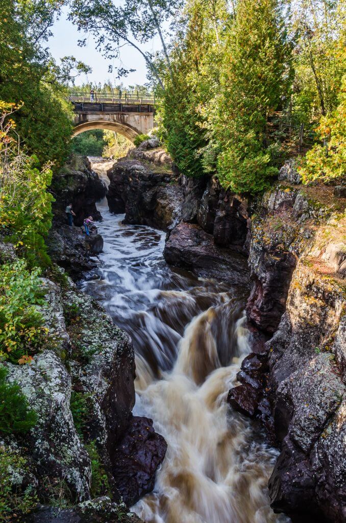
Devil’s Kettle Waterfall
Moderately difficult, Devil’s Kettle Trail is an approximately 2 mile out and back trail located near Grand Marais, Minnesota and situated within Judge C.R. Magney State Park. The trail follows the Brule River, past the Upper Falls, to the Devil’s Kettle Waterfall. There are many stairs on this trail, and benches for resting are found along the way.
This waterfall is a mystery! One side flows 50 feet down to the base of the falls continuing downstream, the other side disappears into a hole with seemingly no escape. Where does the water go? One theory holds that the water flows through underground tunnels out to the Lake. Another theory is that the water meets back up with the river somewhere under the gorge. This has been tested by pouring dyes into the “Devil’s Kettle”, but the colors were not seen at the base of the falls. Leashed dogs are welcome.
Partridge Falls
Located in Grand Portage, Minnesota, Partridge Falls is situated upstream from the popular High Falls on the Pigeon River in Grand Portage State Park. An easy ½ mile out and back trail leads to this impressive 50 foot waterfall.

High Falls – Pigeon River
High Falls Trail is an approximately one mile out and back trail situated within Grand Portage State Park. This pavement/boardwalk trail begins at the park’s Visitor Center parking lot. It is an easy walk that meanders through lush boreal forest to the Pigeon River and the 120 feet High Falls – the tallest waterfall in Minnesota. It is right on the US/Canadian border and can also be viewed at Pigeon River Provincial Park after crossing the border. Leased dogs are allowed.

Middle Falls – Pigeon River
Located within Pigeon River Provincial Park in Ontario’s Superior Country, Middle Falls of the Pigeon River can also be accessed via the Grand Portage State Park. Middle Falls is upstream from the popular High Falls and is approximately 20 feet in height. It can become very wide depending on the season and the rate of flow of the river. You can hike to it from the Pigeon River Ontario Information Centre, or continue north on Highway 61, and turn left on Highway 593 where the fall can be viewed from the roadside.

Kakabeka Falls
Located 30 km (18.6 miles) west of Thunder Bay, Ontario, Kakabeka Falls is often referred to as the “Niagara of the North” as it is the second largest waterfall in Ontario behind Niagara Falls! Located within Kakabeka Falls Provincial Park, this waterfall drops a breathtaking 390 m (130 feet) into the Kaministiquia River and is a must see! There is ample parking just steps from the falls, and a wheelchair accessible boardwalk gives you an excellent vantage point over a pedestrian bridge to observation decks giving you excellent views from multiple angles around the falls.

Cedar Falls
The Cedar Falls Conservation Area is located in Kakabeka, 24.3 miles (39.2 km) west of Thunder Bay, in Ontario’s Superior Country. This is a picturesque walk through a well marked lush evergreen forest that leads to Cedar Creek and Falls. The creek is also a great fishing spot for rainbow and speckled trout.

Dog Falls
Dog Falls is located in Silver Falls Provincial Park in Ontario’s Superior Country. This is a 110 foot (34 m) cascading waterfall that can be reached about 0.9 mile (1.5 km) into the Silver Falls hiking Trail. The waterfall is on the Kaministiquia River and is the largest when the water is flowing high. Hikers should be aware that the Kaministiquia River is controlled by dams and the water levels can change quickly. Move to higher ground if you notice rising water.

Trowbridge Falls
Trowbridge Falls – Yellow Trail and Adventure Trail Loop is located within Thunder Bay within Ontario’s Superior Country. This is an easy 3.5 km loop that hugs Current River and includes two bridges at each side with views of the falls. Consisting of multiple small cascades and rapids, the falls are best viewed when the river is at a lower flow. When the water level is higher, the falls do not show the differing levels. Also, a lower water level allows the more adventurous to dip their toes in the pools or sit on the small ledges to cool off on a summer’s day.

Joe Creek Nature Trail
Located near Pass Lake east of Thunder Bay in Ontario’s Superior Country Region, Joe Creek Nature Trail is a 1.6 km loop trail within the Sleeping Giant Provincial Park. The trail follows a series of waterfalls to the Lake Superior shoreline and is a great family activity if you are camping at the park overnight, or just visiting for the day. The trailhead is located at a small parking area off Highway 597. Leashed dogs are welcome.

Alexander Falls Dam
Approximately 16 km up Highway 528 northwest of Nipigon, in Ontario’s Superior Country Region, you’ll find Alexander Falls Dam and the Alexander Generating Station Powerhouse. A short trail from a small parking area leads you to a viewing platform where you can see the falls and generating station which are located on the mighty Nipigon River. The generation station produces enough electricity to power 60,000 homes each year! A busy boat launch just before the dam is popular with anglers fishing for brook trout, lake trout, walleye and northern bike. The World Record Brook Trout was caught just upriver from here in 1915. The record still stands today. While not an official waterfall when the overflow at Alexander Dam takes place it is a great sight to see!

Cascade Falls
Cascade Falls is an impressive 132 feet (40 m) high and can be seen directly from Highway 11 in Orient Bay. It is best seen in the spring after the winter melt. It is also popular among ice climbers in the winter when the water can freeze up to 33 feet (10 m) thick.

Mazukama Falls
Located about 20 km east of Nipigon in Ontario’s Superior Country Region, the Mazukama Falls Hiking Trail is a favorite among locals and visitors alike. It is a 3.1 km loop, with the option to trek the “wing tip”, a 3.6 km challenging in and out spur that rewards hikers with a spectacular view of Lake Superior. The trailhead is only 20 metres up Camp 81 road at Highway 17. A clearing for parking can be found on the left side of the road across from the trailhead. This trail is rated as difficult with steep climbs, unstable footing and creek crossings. An intermediate fitness level is required, and sturdy footwear is a must. A short hike in, a steep 500 m climb leads you past cascades and waterfalls on the Mazukama Creek. At the top of the climb is a narrow 25 m waterfall that flows from the red rocks of Kama Cliffs. During the rest of the hike you will see old growth cedar forest, massive fern covered boulders and talus slopes. The winter is an excellent time to visit, as the flow of the creek results in spectacular ice formations.

Kama Falls
This is a little known waterfall nestled into the forest, not far from the highway. Kama Falls is situated approximately 25 km east of Nipigon along Highway 17 just a few minutes passed Mazukama Falls Hiking Trail. Once at the Kama Cliffs trailhead, you will find a narrow path just to the west. If you listen closely, you will be able to hear the sound of the falls before before even setting foot on the path. This is a great place to begin or end your hike up the Kama Cliffs Trail.

Rainbow Falls
Located within the Rainbow Falls Provincial Park just east of Rossport, Rainbow Falls can be reached by accessing the Whitesand Lake location of the park. A series of stairs leads you along the falls via a small portion of the 52 km Casque Isle Trail. Platforms and ledges along the way allow for a closer look, and benches are provided to just have a rest and enjoy the view. At the bottom you will find a bridge that traverses the cascading falls.

Aguasabon Lower Falls
These falls can be viewed from the beautiful Terrace Bay Beach on Lake Superior. The Aguasabon Lower Falls cascade over craggy rock just above the mouth of the river. Visitors can get a closer look at these smaller falls by paddleboat or kayak. The beach offers a wheelchair accessible kayak launch, boat launch, restroom, picnic area and ample parking.

Aguasabon Falls and Gorge
Located just 1 km west of Terrace Bay in Ontario’s Superior Country Region, the Aguasabon Falls & Gorge is accessible via a large parking area. A wheelchair accessible boardwalk leads you to an observation platform directly over the 30.4 m drop. During spring when the water flow is highest, visitors are rewarded with a refreshing mist as they view the falls, gorge and Lake Superior. This is also an access point to the Casque Isle Trail, and includes amenities such as a picnic area, RV friendly parking, and restrooms.

Mink Creek Falls
Mink Creek Falls is located just 28 km west of Marathon in Ontario’s Superior Country Region. The trail is approximately ½ km west where Mink Creek crosses Highway 17. It is relatively easy to find, although it can be missed due to lack of signage. The falls are a short, five minute walk down a rugged trail. The creek is not very wide, but the waterfall is larger and more impressive than you might expect.

Chigamiwinigum Falls
Pukaskwa National Park, in Ontario’s Superior Country Region, is home to the Chigamiwinigum Falls. These falls run under the park’s White River Suspension Bridge and are the final set of rapids before the river meets the Lake. The Ojibway word “Chigamiwinigum” means “first portage from the lake”. The cascades are just under 1 km long, and can be reached via the Pukaskwa Coastal Trail via a 3-4 hour hike.

Cascade Falls
Also situated in Pukaskwa National Park are the Cascade Falls, unique and remote waterfalls found at the mouth of the Cascade River rushing over a sheer cliff into Lake Superior. This unique and remote waterfall is right at the mouth of Cascade River and rushes over a sheer cliff into Lake Superior. The falls can be accessed by chartering a boat or by paddling the Coastal Paddling Route launching from Hattie Cove. The beach beside the falls offers a nice spot for paddlers to rest and camp.

Magpie Scenic High Falls
Magpie Scenic High Falls is a picturesque waterfall that is also known as High Falls, Scenic High Falls, Magpie Falls and High Falls of the Magpie River. Located in Wawa, the falls stand 22.8 m high and 38 m wide. Adjacent to the parking area is the main lookout and a picnic area. There is also a short trail to the right of the falls that provides additional vantage points. There is a sign off Highway 17 to that will direct you to the site. Amenities include accessible restrooms, a picnic shelter, BBQs and RV/Trailer parking.

Silver Falls
Silver Falls is located near Wawa, off Highway 17, approximately 3 km down Mission Falls Road. There are wayfinding signs to lead you to the site, and there is a parking area just before you reach the bridge. The falls can be viewed from the bridge or you can make your way down to the river for a closer look. A kayak or canoe gets you even closer!

Baldhead River Falls
Situated in Lake Superior Provincial Park, Baldhead River Falls is one of many sights along the Orphan Lake Trail. Accessing the falls via the hiking trail takes approximately 1-2 hours. These falls drop 10-15 feet into the Baldhead River, and reach approximately 200 feet across. A bridge that crosses the river allows hikers to view the falls from both sides.

Sand River Trail
The Sand River Trail, 3.5 km out and back that follows the banks of the Sand River, is situated within the Lake Superior Provincial Park. The river has many cascades and waterfalls that you will pass on this trail, some dropping up to 10-15 feet. The trail leads to a back-country camp site that is popular among paddlers. Leashed dogs are allowed.

Agawa Falls
Agawa Falls are located within the Lake Superior Provincial Park and can be accessed via the 24 km Towab Trail. This impressive 22.8 m high waterfall is located near the end of the trail, on the Agawa River. It is the tallest waterfall in the park and is worth the hike if you have the time. There are campsites along the trail if you would like to stay overnight.

Otter Creek Falls
Situated in Agawa Canyon Park, Otter Creek Falls is one of three waterfalls found within the park. The falls can be reached via the popular Agawa Canyon Train Tour, departing from Sault Ste. Marie. 13.7 m in height, Otter Creek Falls is the smallest of the three, and is fed by small beaver ponds above the canyon. It drops into a lateral fault in the granite base. It is best viewed in the spring or after a heavy rain, but regardless of the flow autumn is the best for observing the fall colors.

Black Beaver Falls
The second highest of the three waterfalls of Agawa Canyon Park, Black Beaver Falls is an impressive 53.3 m. It can only be reached via the Agawa Canyon Train Tour, and the base is just a 10 mins walk from the train. On your stroll you will pass moss covered rocky slopes to the observation platforms at North and South Black Beaver Falls. The creek splits in half before falling into the canyon, essentially creating the two sides.

Bridal Veil Falls
The largest of the Agawa Canyon Park falls, Bridal Veil Falls has jaw dropping height of 68.5 m! The falls are only accessible via the popular Agawa Canyon Train Tour, and can be seen from the train as you enter the canyon. From the train, you can access the falls via a short walk on a well maintained, easy trail.

Batchawana Falls
Located just north of Batchawana Bay Provincial Park, Batchawana Falls can be accessed via Tribag Mine Road off Highway 17. It is a 7 km drive over a rough logging road, as such all-terrain vehicles with four-wheel drive are highly recommended on this quest. Once at the site, these 4.5 m high falls are close to the road and easy to access.

Chippewa Falls
Approximately 55 km north of Sault Ste. Marie right off the Trans Canada Highway, you will find a roadside waterfall called Chippewa Falls. This 25 m tall drop is best viewed after the winter melt when the water level is highest. A rest area adjacent to the falls is an excellent place to stretch your legs and enjoy a picnic. There is also a Group of Seven interpretive panel at this location, as it was an inspiration to artist A.Y. Jackson.

Crystal Falls
Crystal Falls is situated in Sault Ste. Marie within Kinsmen Park, in the heart of the Hiawatha Highlands Conservation Area. A boardwalk leads you along the Crystal Creek, where at the left side of the falls you can climb stairs to access several viewing platforms. Only a 10 min walk from the road, you do not want to miss this majestic, 18 m high waterfall!

Minnehaha Falls
Located on the Crystal Creek a few hundred yards downstream from Crystal Falls, Minnehaha Falls is comprised of a series of drops between 3-6 m as it enters into a narrow gorge. A pedestrian walkway gives you an excellent view of the falls. Kinsmen Park, where is the falls are located, boasts excellent walking trails in a natural setting. It is worth setting aside some time on your Lake Superior Circle Tour adventure to explore!
Plan to Visit Lake Superior Waterfalls
Well, I hope you enjoyed my complete list of all things water, rock and magic around the Lake Superior Circle Tour. With so many to choose from, I hope this list helped you discover a few waterfalls you didn’t know about, or inspired you to plan stops at those roadside falls you’ve always wanted to explore! Don’t forget – “Visit a Waterfall” is a square on your Lake Superior Circle Tour Bingo card, so make sure to cross it off when you experience that first flow and drop. If you’re interested in traveling the Lake Superior Circle Tour make sure to order the official magazine – the Lake Superior Circle Tour Adventure Guide! You can also use the online trip planner and Lake Superior Circle Tour Mobile App. Now get out there, and chase those waterfalls!


