
As people travel the Trans Canada Highway along the top of Lake Superior they may not realize just how much history and development the region has seen in the last 150 years; not to mention the beautiful landscapes and ocean side setting.
Today the road and rail smoothly etches its path through the Canadian Shield after dynamite and human toil blasted through. The roadway bisects the ever present boreal forest where travelers experience ribbons of green, gray and Lake Superior blue. Passengers take in the shock and awe of the vastness of this part of the world and wonder how people survived the isolation.

Since the beginning of human existence on this land, hunting, fishing and gathering by the First Nations provided subsistence along these barren shoreline and islands that stretch from Marathon to Thunder Bay.
In the 1700’s, the fur trading Coureur des Bois used the waterways to move their product and were precursors to the exploitation of other resources the area retained. Collecting raw materials needed skilled men to graft in the mines, cut down timber and trawl for fish. Shipping also played a critical role in getting the product to market.

Passenger and cargo vessels started to venture further in 1855 when the Soo Locks at Sault Ste. Marie connected Lake Huron to Superior. Navigation at that time was accomplished by compass, sextant and by following the stars. The captains were not aided at that time by any lighthouse and navigation charts were rudimentary. Therefore the passage relied on the captain’s experience.
Lake Superior vessels would set sail or be powered by steam from Sault Ste. Marie towards the northwest and the Lakehead, now known as Thunder Bay. Crews had to keep a sharp lookout to anticipate any oncoming hazards. Just imagine adding in some fog?

Considering these hazards to mariners, the Dominion of Canada’s Department of Marine and Fisheries in 1873 commissioned three lighthouses, two on Michipicoten Island southwest of Wawa, and one at Point Porphyry located 43 km east of Thunder Bay.
Point Porphyry Lighthouse was the first light in the lighthouse trail to emerge. Eighteen more lighthouses would later be illuminated from Thunder Bay to Marathon.
Many of these Superior lights are perched on islands with names like Angus, Battle, Welcome, Victoria, Lamb and Pie. Only one lighthouse was built on the mainland which was at Thunder Cape at the feet of the Sleeping Giant.

Three basic aids to navigation accompanied each light station. First the light needed to be high enough over the water to take into consideration the curvature of the earth. The second aid was that lighthouse buildings needed to distinguishable in daylight; a healthy dose of whitewashing took care of that. Finally, when the fog rolled in, which was often, the light would became obstructed so a fog alarm was added. Light keepers were sometimes required to operate the horn for days on end. Imagine trying to sleep when you have to maintain the equipment, feed yourself and provide for your family?

The lighthouse trail was a line of defense to alert vessels of any hazards in the area. The first and last lighthouse on the waterway is the Thunder Bay Main Light. Being built in 1940, it’s the youngest lighthouse and sits perched atop the break water on Thunder Bay’s waterfront with the majestic Sleeping Giant in the background. In May of 1971 the SS Simcoe shifted the light from its base a couple of meters after engine trouble caused it to collide into the light!

Victoria Island Light built in 1881, located southwest of Thunder Bay is the first island in the archipelago of islands that provided a narrow entrance for vessels to reach the former towns of Port Arthur and Fort William.
Pie Island, from its original French name Le Pâté, referred to the island south of Thunder Bay that looked like a meat pie with crust. A circular mesa of rock rises 450 meters on the west side of the island and can be seen from the City of Thunder Bay. The 1895 lighthouse was built on the western side of the island; it provides safety to mariners by marking one boundary of channel visible between the island and the mainland.
The Welcome Island Light was built in 1905 some 45 meters above the water, high on a cliff face. Local mariners like to hike up the trail to see the views and the huge open waters of Thunder Bay, partially framed by the Sleeping Giant. As most were at the time, the island light was later automated and destaffed in 1985.
Vessels approaching from the south will see Angus Light on their port (left) side. Constructed on a craggy island surrounded by 120 meters of deep water, the light has clung to the rock since 1927. Two ships have become wrecked here; the Monkshaven in 1905 and the Leafield in the devastating November storm of 1913. This also marks the western boundary of Parks Canada’s, Lake Superior National Marine Conservation Area (NMCA).
Trowbridge Island, located inside of the NMCA near the feet of the Sleeping Giant contains a glass and brass framed light making it unique today. The Fresno lens stands ten feet high and sits atop a concrete poured tower. Standing 43 meters above the water the light can be seen from as far away as Passage Island and Isle Royale where all commercial shipping traffic passes. The light has witnessed three wrecks; the Theano in 1906 and in 1953 a collision between the Scotiadoc and the Burlington took place. In 259 meters of water the Scotiadoc’s watery grave has been recognized as the deepest shipwreck on Lake Superior!

Nearby, the silver mine of Silver Islet could be seen by both Trowbridge and Porphyry lights. Silver was mined at Silver Islet in the 1880’s producing 3.5 million dollars of silver for sale on markets far away, as logging companies collected timber from the forest.
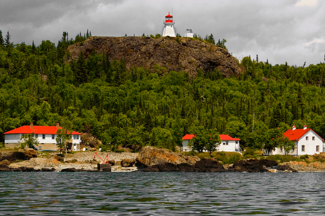
Having guided steamers east and west for 150 years, Porphyry’s Light provides visitors with an opportunity to explore. Since it was automated in 1989, volunteers help protect the wildlife, show visitors the volcanic black sands and panoramic views. In the 1880’s the island served as a home port to a fleet of fishing vessels harvesting fish in Black Bay.
In the middle of the lighthouse trail and NMCA, Lamb Island Lighthouse has been designated as a Canadian Heritage Lighthouse. Its purpose was to illuminate the hazards of the north shore islands but also to provide direction to vessels wanting to enter the Nipigon Straits to Nipigon Bay. In Admiral Bayfield’s chart of 1874 one can see the route passenger ships would take to reach the towns of Red Rock and Nipigon.

Battle Island Light situated near Rossport and established on the eastern most extremity of the archipelago, was built in 1877. The steamer Ontario was wrecked on the eastern shore of Battle Island in 1899 and a boiler can still be seen in the water. In 1915 the current concrete tower was constructed and is the sister of the one built at Peggy’s Cove Light near Halifax.
The last island lighthouse on the lighthouse trail is situated 13km from Terrace Bay and also serves as a provincial park. The Slate Islands Lighthouse has the highest elevation of all the lights at 68 meters above the water. There were no known shipwrecks on this island which is visited by many boaters in the summer months. The island is unique for its heard of caribou and a meteoritic shatter cone.
Since the start of navigation these lighthouses on Canada’s top of Lake Superior islands have been protecting vessels from the harsh realities of the Canadian Shield. As Parks Canada’s NMCA on Lake Superior grows, so will the opportunity to explore further these beacons of our past. Today these lights offer an unseen snapshot of the early days in the isolation and beauty surrounding of Lake Superior.


